Digital Building Maps for First Responders
Having accurate maps of the inside of buildings that you can easily access via different digital platforms, from web to mobile, can be critical for First Responders when assessing the situation as t enfolds. No one wants to think about the possibility of negative or traumatic events occurring but we should be making sure those who are first on the ground, whether this is the Police, Ambulance or Fire and Rescue services, have access to the best tools available to do their job.
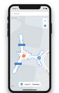
Often the only available maps of a building are in paper form and typically out of date, so having digital maps that are accurate in nature will help First Responders in their own process to create efficiencies. Also even tracking Responders’ location in the building and helping guide them to the event in hand will also help to improve response times. This was also mentioned in Apple’s recent WWDC event and with the new lightweight data formats, the tools are available now to deliver this.
How do we fit in?
Point provides the tools that enables you to view and interact with the digital maps across multiple formats – so you can add this tool into the existing solutions that are in use.
Leave a Reply
You must be logged in to post a comment.